
Use the data in the BlackHills folder and Sturgis83 geodatabase to answer the following questions. Because solution methods can vary, your answers may be slightly different from the ones in the back of the book. The Madison Limestone is an important aquifer. Citizens are concerned about gas or chemical trucks overturning on roads and causing contamination. What is the total length of roads crossing the Madison, in kilometers?
Read moreTextbook Solutions for Mastering ArcGIS (WCB Geography)
Chapter 10 Problem 1
Question
Use the data in the BlackHills folder and Sturgis83 geodatabase to answer the following questions. Because solution methods can vary, your answers may be slightly different from the ones in the back of the book.
The Madison Limestone is an important aquifer. Citizens are concerned about gas or chemical trucks overturning on roads and causing contamination. What is the total length of roads crossing the Madison, in kilometers?
Solution
Step 1 of 3
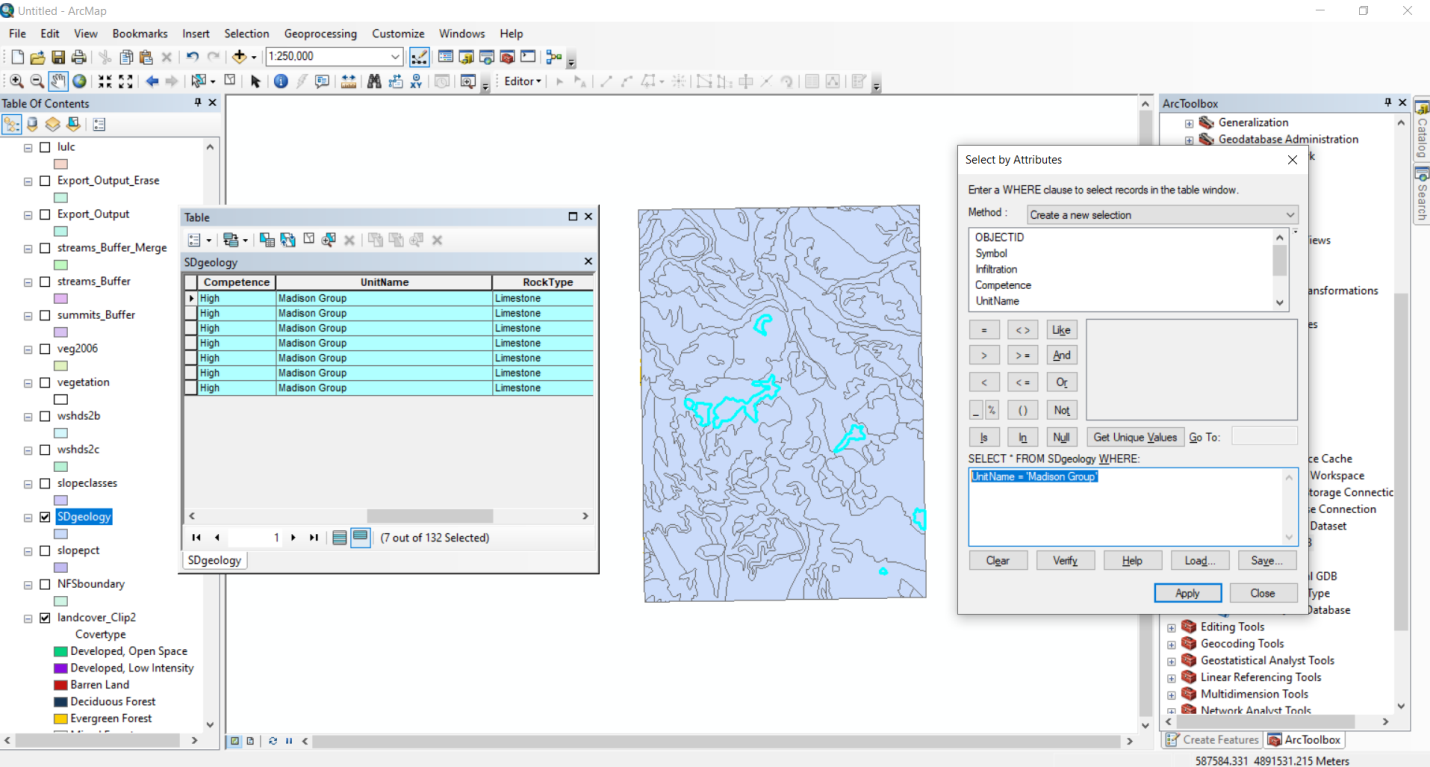
For selecting Madison limestone we have to place a query in the SD geology layer as Unit Name = 'Madison Group' query and the output is shown below:
Subscribe to view the
full solution
full solution
Title
Mastering ArcGIS (WCB Geography) 7
Author
Maribeth H. Price
ISBN
9780078095146
Use the data in the BlackHills folder and Sturgis83 geodatabase to answer the following
Chapter 10 textbook questions
-
Chapter 10: Problem 1 Mastering ArcGIS (WCB Geography) 7
-
Chapter 10: Problem 2 Mastering ArcGIS (WCB Geography) 7
Use the data in the BlackHills folder and Sturgis83 geodatabase to answer the following questions. Because solution methods can vary, your answers may be slightly different from the ones in the back of the book. The infiltration rate of the geological substrate is a strong factor in evaluating the spill hazards for roads. Create a map of all the roads based on the infiltration capacity of the geology, using appropriate symbols to indicate hazard. Capture your map.
Read more -
Chapter 10: Problem 3 Mastering ArcGIS (WCB Geography) 7
Use the data in the BlackHills folder and Sturgis83 geodatabase to answer the following questions. Because solution methods can vary, your answers may be slightly different from the ones in the back of the book. The use of a road is another factor in evaluating spill hazards. Create a new field in the roads feature class with a hazard rating of 3 for primary roads, 2 for secondary roads, and 1 for primitive roads. Create a map and capture it.
Read more -
Chapter 10: Problem 4 Mastering ArcGIS (WCB Geography) 7
Use the data in the BlackHills folder and Sturgis83 geodatabase to answer the following questions. Because solution methods can vary, your answers may be slightly different from the ones in the back of the book. Now create new field for a hazard index based on both infiltration and use, adding them together. What is the range of values for the index? Create a map of the roads based on the hazard index. Capture the map.
Read more -
Chapter 10: Problem 5 Mastering ArcGIS (WCB Geography) 7
Use the data in the BlackHills folder and Sturgis83 geodatabase to answer the following questions. Because solution methods can vary, your answers may be slightly different from the ones in the back of the book. Rangeland can cause significant impacts on surface water quality. Using the lulc and wsheds2b feature classes, create a table showing the area of rangeland in each watershed. (Include both herbaceous and mixed rangeland categories.)
Read more -
Chapter 10: Problem 6 Mastering ArcGIS (WCB Geography) 7
Use the data in the BlackHills folder and Sturgis83 geodatabase to answer the following questions. Because solution methods can vary, your answers may be slightly different from the ones in the back of the book. Areas that are within 300 meters of both streams and primitive roads are the most popular places for fishing. Create a map showing these areas. Capture your map.
Read more -
Chapter 10: Problem 7 Mastering ArcGIS (WCB Geography) 7
Use the data in the BlackHills folder and Sturgis83 geodatabase to answer the following questions. Because solution methods can vary, your answers may be slightly different from the ones in the back of the book. The fishing areas in #6 should be restricted to areas within the national forest (OWNER = NFS in the vegetation feature class). Create a revised map showing the public access fishing areas in green and the private fishing areas in red. Capture your map
Read more -
Chapter 10: Problem 8 Mastering ArcGIS (WCB Geography) 7
Use the data in the BlackHills folder and Sturgis83 geodatabase to answer the following questions. Because solution methods can vary, your answers may be slightly different from the ones in the back of the book. You need a feature class that shows polygons based only on infiltration and only within the wshds2b area. Symbolize this layer based on infiltration. Capture your map.
Read more -
Chapter 10: Problem 9 Mastering ArcGIS (WCB Geography) 7
Use the data in the BlackHills folder and Sturgis83 geodatabase to answer the following questions. Because solution methods can vary, your answers may be slightly different from the ones in the back of the book. The Forest Service is concerned about septic systems contaminating the Madison Limestone. Create a map showing private land (OWNER = PVT in the Vegetation layer) on the Madison. Capture the map.
Read more -
Chapter 10: Problem 10 Mastering ArcGIS (WCB Geography) 7
Use the data in the BlackHills folder and Sturgis83 geodatabase to answer the following questions. Because solution methods can vary, your answers may be slightly different from the ones in the back of the book. The Forest Service is considering adopting a policy to not cut timber within 200 meters of a primary road (TYPE = P). Assuming that cutting timber includes all SSTAGE96 LIKE 4*, determine the total area in square kilometers lost to harvesting if this policy were adopted. Capture a map showing the off-limits areas.
Read more